**4-inch Dual-Orientation, Glove-Friendly Touchscreen Display****Preloaded Garmin Topo Aus/NZ maps, and includes 1-year Garmin BirdsEye Satellite Imagery subscription.**The Montana 680T features a bold, colour touchscreen, dual-orientation display and includes a 1-year BirdsEye Satellite Imagery subscription.
It also comes preloaded with Garmin Topo Australia and New Zealand V5 full version, giving you topographic and street maps for both countries.
It come with a 3-axis tilt-compensated compass, barometric altimeter and access to both GPS and GLONASS satellites for improved positioning and typically faster fixes.
The free BaseCamp software lets you view and organise maps, waypoints, routes and tracks. This free trip-planning software even allows you to create Garmin Adventures that you can share with friends, family or fellow explorers. BaseCamp displays topographic map data in 2-D or 3-D on your computer screen, including contour lines and elevation profiles. The 4-inch sunlight-readable touchscreen display offers crystal clear, enhanced colours and high-resolution images. Its easy-to-use interface means youll spend more time enjoying the outdoors and less time searching for information.
**8 Megapixel Camera with Autofocus****Automatically geotags photos.**Capture locations and memories with Montana 680ts 8 megapixel digital camera. Each photo is automatically geotagged with coordinates, allowing you to navigate back to that exact spot in the future.
Keep track of your photos and see their locations on a map using the free BaseCamp software.
**Barometric Altimeter, Electronic Compass &; Wireless Sharing****3-axis tilt-compensated compass and altimeter sensors.**The Montana has a 3-axis, tilt-compensated electronic compass - which shows your heading even when you're standing still, without holding it level.
The barometric altimeter tracks changes in pressure to pinpoint your precise altitude, and you can even use it to plot barometric pressure over time, which can help you keep an eye on changing weather conditions.
With the Montana you can share your waypoints, tracks, routes and geocaches wirelessly with other compatible Garmin device users. So now your friends can also enjoy your favourite hike or cache simply press "send" to transfer your information to similar units.
Waterproof and rugged****Can survive 1m of H20 for 30 minutesThe Montana is waterproof to IPX7 standards, so you can use it in any weather. You can even use it around water without worrying about damage.
With the Montana, you can measure an area for farming and other rural and marine applications. Area measurement is simple and fast. Just walk, drive or ride around the perimeter to be measured, press a button, and there you have it. A really productive feature for farmers, botanists, agronomists, graziers, oyster and fish culture, salt-works... etc etc. For farming, agriculture, agronomy, aquaculture and related endeavours, the Montana 680T measures distances and directions between points, and area measurements.
Montana 680T features a one-of-a-kind dual battery system. You'll have the option of using the rechargeable lithium-ion pack or traditional AA alkaline batteries whichever suits your needs better.
Both durable and waterproof, Montana 680T is built to withstand the elements. Bumps, dust, dirt, humidity and water are no match for this rugged navigator. No matter the setting on the trail, in the car, or on the boat, - Montana is right at home.
**Geocache ready****Load the GPX cache file. Head out.**The Montana is also geocaching friendly, supporting geocaching GPX files for downloading geocaches and details straight to your unit.
It stores and displays key information, including location, terrain, difficulty, hints and descriptions, which means no more manually entering coordinates and paper print outs!
Simply upload the GPX file to your unit and start hunting for caches. The track manager feature helps organize and navigate through waypoints/routes/ and track logs (easily start/stop recording tracklogs).
Key Features
**Unit Dimensions (W x H x D):7.48 x 14.42 x 3.64 cmDisplay Size (W x H):5.06 x 8.93 cm; 10.2cm diagDisplay Resolution (W x H):272 x 480 pixelsDisplay Type:Bright, transflective 65k colour TFT, dual-orientation touchscreen; sunlight readableWeight:289 g with included lithium-ion battery packBattery:Rechargeable lithium-ion (included) or 3 AA batteries (not included); NiMH or Lithium recommendedBattery Life:**Up to 16 hours (lithium-ion); up to 22 hours (AA batteries)**Waterproof:**Yes (IPX7)**Floats:NoHigh-sensitivity Receiver:YesInterface:**High-speed USB and NMEA 0183 compatible
Maps &; Memory
**Basemap:YesPreloaded Maps:Yes, Garmin Topo Australia &; New ZealandAbility to Add Maps:YesBuilt-in Memory:8 GBAccepts Data Cards:**microSD card (not included, up to 32GB)**Waypoints:4000Routes:200Track Log:**10,000 points, 200 saved tracks
Features
**Automatic Routing (turn by turn routing on roads):**Compatible (when using optional mapping for detailed roads)**Electronic Compass:**Yes (tilt-compensated, 3-axis)**Touchscreen:YesBarometric Altimeter:YesCamera:**Yes, (8 megapixel with autofocus; automatic geo-tagging)**Geocaching-friendly:**Yes (paperless)**Custom Maps Compatible:YesPhoto Navigation (navigate to geotagged photos):YesOutdoor GPS Games:NoHunt/fish Calendar:YesSun &; Moon Information:YesTide Tables:**Yes (with optional Bluechart mapping)**Area Calculation:YesCustom POIs (ability to add additional points of interest):YesGarmin Connect Compatible
(online community where you analyse, categorise and share data):**Yes
Owners Manual
 United States of America
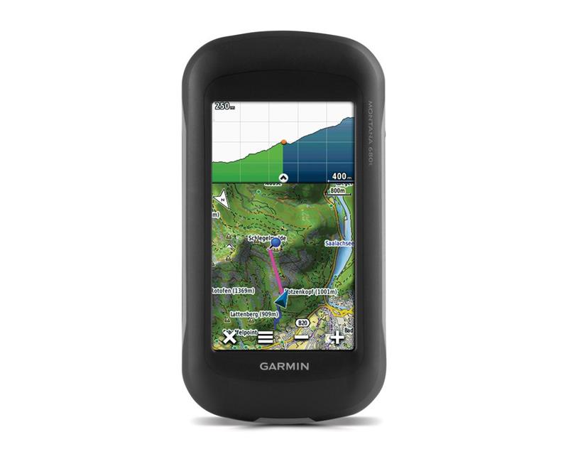
Doll beautiful from Vereeniging, South Africa
Great value for money and very happy!!
Sweet Quail from New Orleans, United States
They have the absolute lowest price anywhere, ordering is easy and the delivery is quick.
Cheeky girl from Bern, Switzerland
Much better quality than expected, groupspree has fast delivery
1ddreamoutloud from Barcelona, Spain
I got this and it works so well
Ghost from Tampico, Mexico
Top product nothing more to say